Understanding WESP-AC: Measuring the Ecological Value of Our Wetlands
By: Fundy Biosphere Region 
As climate change and land development continue to influence how we manage our landscapes, understanding the role wetlands play in climate resilience has never been more important. Wetlands store carbon, reduce flooding, filter water, and provide critical wildlife habitat.
At the Fundy Biosphere Region, one of the primary tools we use to evaluate wetlands is the Wetland Ecosystem Services Protocol Atlantic Canada (WESP-AC).
What is WESP-AC & Why Is It Important?
The Wetland Ecosystem Services Protocol Atlantic Canada (WESP-AC) is a rapid, science-based assessment method used to evaluate the ecological functions and services that wetlands provide. Rather than focusing solely on wetland size, WESP evaluates how well a wetland functions.
Two wetlands of similar size can perform very differently depending on vegetation, hydrology, connectivity, surrounding land use, and soil conditions. WESP allows us to move beyond assumptions and measure wetland value in a consistent and transparent way.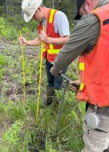
WESP assessments help to:
- Identify high-functioning wetlands
- Support conservation and land protection decisions
- Inform restoration opportunities
- Provide baseline data for long-term monitoring
- Strengthen climate adaptation and ecological corridor planning
How Fundy Biosphere Region Conducts WESP Assessments
Our process begins with desktop analysis. Using aerial imagery and mapping tools, we identify wetlands within the Fundy Biosphere Region and create a detailed map of the wetland we intend to assess.
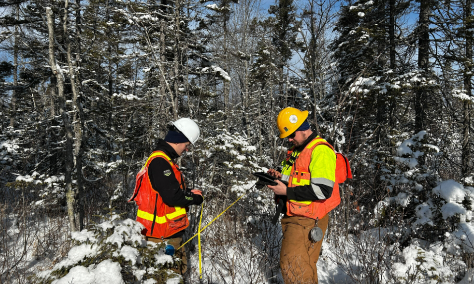
Once on site, we complete the WESP-AC field form, which evaluates hydrology, vegetation, habitat quality, water storage capacity, and landscape connectivity.
During fieldwork, we:
- Differentiate wetland types (e.g., bog, fen, marsh, swamp) based on vegetation, hydrology, and soil conditions
- Observe and record any disturbances, such as drainage, infilling, invasive species, adjacent land-use pressures, or other alterations affecting wetland condition
During the WESP assessment, we also measure peat moss or organic soil depth at three locations within the wetland to estimate carbon storage potential:
- At the edge between the wetland and upland
- Midway between the edge and the centre
- At the centre of the wetland
These measurements allow us to calculate an average peat depth, which contributes to carbon storage estimations for the site.
This combined approach provides both a functional assessment of ecosystem services and a clearer understanding of carbon storage potential.
Fundy Biosphere’s Accomplishments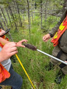
Last summer, Fundy Biosphere staff completed 20 WESP assessments across a range of wetland types and land ownership categories within the region.
For the upcoming field season, we plan to complete another 20 WESP assessments, continuing to build a comprehensive understanding of wetland function and ecological value across the landscape.
The data collected directly supports conservation planning, ecological corridor development, species-at-risk considerations, and climate-focused land management throughout the Fundy Biosphere Region.
Looking Ahead
Wetlands are dynamic systems. Their function can shift due to land-use change, climate impacts, invasive species, or restoration efforts. By continuing to conduct and revisit WESP assessments over time, we can monitor changes and ensure that conservation actions deliver measurable, long-term ecological and climate benefits.
Understanding wetland function is a critical step in protecting the natural systems that protect us.
To learn more about how WESP assessments are being applied across the Fundy Biosphere Region, follow along on our blog and social media.